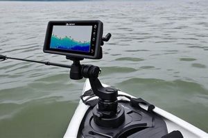
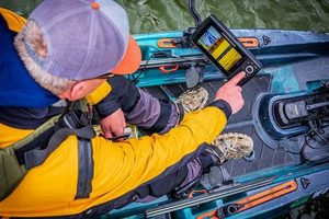
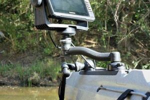
A bundled collection of equipment designed for anglers using kayaks typically includes a specialized sonar device, mounting hardware, and often a power supply. This integrated system provides the user with real-time underwater information, such as water depth, bottom structure, and fish location, directly on a compact display unit. An example might comprise a transducer specifically designed for kayak mounting, a portable display with GPS capabilities, and a rechargeable battery pack.
Such systems offer significant advantages for kayak anglers. The ability to pinpoint fish-holding locations enhances fishing efficiency and success rates. Compact size and portability are paramount, ensuring minimal impact on kayak maneuverability. Historically, anglers relied on experience and intuition to locate fish. Modern technology, however, provides a distinct advantage, allowing for a more strategic and informed approach to fishing, even in unfamiliar waters. The evolution of these compact, integrated systems reflects the growing popularity of kayak fishing and the demand for specialized equipment.
This discussion will further explore the critical components within these systems, including various sonar technologies, transducer types, and mounting considerations. Power management strategies, display features, and integration with other kayak electronics will also be examined. Furthermore, the benefits of these systems for different fishing styles and target species will be addressed.
Tips for Selecting and Utilizing Integrated Sonar Systems for Kayaks
Choosing and implementing a suitable system requires careful consideration of several factors. The following tips offer guidance for maximizing the effectiveness and enjoyment of these tools.
Tip 1: Transducer Selection is Crucial: Consider the target fishing environment. In-hull transducers offer convenience but may be less effective in shallow water or on faster-moving kayaks. Transom-mount or trolling motor-mounted transducers provide better performance in these situations.
Tip 2: Prioritize Display Clarity and Size: A display that is easily readable in direct sunlight and offers sufficient screen size for clear data interpretation is essential. Consider features such as adjustable screen brightness and contrast.
Tip 3: Power Management is Key: Portable systems rely on battery power. Choose a battery with sufficient capacity for the planned fishing duration. Consider power-saving features and carry a backup power source if necessary.
Tip 4: Mounting Location Impacts Performance: Ensure the transducer is mounted correctly and in a location that minimizes interference from the kayak’s hull or other equipment. Follow manufacturer instructions carefully for optimal placement.
Tip 5: Understand Sonar Technology: Familiarize oneself with the principles of sonar and the specific features of the chosen unit. Learn to interpret the displayed information effectively, including depth readings, bottom contours, and fish arches.
Tip 6: Integrate with Other Electronics: Consider compatibility with other kayak electronics, such as GPS units and chartplotters. Integration can enhance navigation and fishing efficiency.
Tip 7: Practice Makes Perfect: Spend time practicing with the system in different water conditions and depths. This will improve interpretation skills and allow for a more informed approach to fishing.
By considering these tips, anglers can select and utilize these systems effectively, enhancing their fishing experience and increasing their chances of success. Proper planning and execution are crucial for maximizing the benefits of this technology.
This discussion concludes with an overview of popular models and recommendations for specific fishing applications. A comprehensive understanding of these systems empowers anglers to make informed decisions and optimize their on-the-water performance.
1. Transducer Type
Transducer selection significantly impacts the effectiveness of a kayak fish finder package. The transducer acts as the system’s eyes underwater, transmitting and receiving sonar signals. Choosing the correct transducer type depends heavily on the intended fishing environment and target species. Different transducer types offer varying performance characteristics, affecting factors such as depth penetration, cone angle, and sensitivity.
For example, in shallow freshwater environments targeting panfish, a high-frequency transducer with a wider cone angle provides excellent detail and covers a broader area. Conversely, deep-sea anglers pursuing larger pelagic species require a lower-frequency transducer with a narrower cone angle for greater depth penetration and precise target identification. Furthermore, the kayak’s hull material and mounting location influence transducer choice. In-hull transducers offer convenience but may suffer performance degradation in certain kayak hull materials. Transom-mount transducers provide more flexibility and improved performance in turbulent water.
Understanding the relationship between transducer type and overall system performance is crucial for maximizing fishing success. A mismatched transducer can lead to inaccurate readings, missed targets, and frustration. Selecting the appropriate transducer ensures the fish finder package delivers accurate, reliable data optimized for the specific fishing application, ultimately improving angling effectiveness.
2. Display Clarity
Display clarity represents a critical component of an effective kayak fish finder package. A clear, easily readable display translates the raw sonar data into usable information, directly impacting an angler’s ability to interpret underwater environments. Factors influencing display clarity include resolution, screen size, color palette, and brightness/contrast adjustments. A high-resolution display renders sharper images of bottom structure, fish, and other underwater objects. Adequate screen size ensures comfortable viewing, particularly in challenging lighting conditions.
Consider a scenario where an angler utilizes a fish finder with a low-resolution display in bright sunlight. Distinguishing subtle bottom contours or identifying individual fish becomes difficult, hindering effective fishing. Conversely, a high-resolution display with adjustable brightness ensures optimal visibility, allowing the angler to interpret subtle details and react accordingly. Screen size also contributes significantly to practical usability. A larger display facilitates easier interpretation, especially when displaying complex sonar data or incorporating split-screen functionalities like mapping alongside sonar readings.
Optimized display clarity directly correlates with enhanced fishing efficiency. Accurate interpretation of underwater features allows anglers to identify promising fishing locations, adjust lure presentations, and ultimately increase their chances of success. Investing in a fish finder package with a high-quality display yields significant returns in terms of improved angling performance. Challenges may arise from environmental factors like direct sunlight or water glare, highlighting the importance of adjustable brightness and contrast settings. Ultimately, prioritizing display clarity ensures that the sophisticated technology within the fish finder translates into actionable, readily understandable information for the angler.
3. Power Source
Reliable power delivery is essential for consistent operation of a kayak fish finder package. The power source directly impacts the duration of use and overall system performance. Understanding power requirements and available options is crucial for maximizing time on the water and ensuring uninterrupted functionality.
- Battery Type and Capacity
Battery selection significantly influences operating time. Common options include lead-acid, lithium-ion, and nickel-metal hydride batteries. Lithium-ion batteries generally offer higher energy density and lighter weight, enabling longer operation with reduced overall kayak load. Capacity, measured in ampere-hours (Ah), dictates the duration a battery can power the fish finder. Higher capacity batteries extend operating time but may also increase weight and cost. Matching battery capacity to anticipated usage ensures uninterrupted operation throughout a fishing trip. For instance, a smaller capacity battery might suffice for shorter trips, while extended excursions necessitate higher capacity options.
- Power Consumption and Management
Fish finders consume power at varying rates depending on features, display brightness, and transducer usage. Understanding power consumption patterns allows for effective power management. Dimming the display, utilizing power-saving modes, and managing transducer output can extend battery life. Calculating anticipated power consumption based on planned usage assists in selecting a battery with sufficient capacity. For example, extended use of high-power sonar functions will deplete battery reserves faster than basic depth finding. Careful power management strategies optimize battery life, maximizing the duration of fish finder operation.
- Charging and Maintenance
Proper charging and maintenance practices extend battery lifespan and ensure reliable performance. Utilizing appropriate chargers and following manufacturer guidelines prevents premature battery degradation. Regularly checking battery health and storing batteries in optimal conditions maintains long-term functionality. Neglecting proper charging and maintenance can lead to reduced battery capacity and potentially equipment failure. For example, overcharging or deep discharging batteries can significantly shorten their lifespan. Consistent adherence to recommended maintenance procedures safeguards the power source, ensuring reliable operation of the fish finder package.
- Alternative Power Sources
While batteries represent the primary power source for most portable kayak fish finder packages, alternative options exist for specific scenarios. Kayaks equipped with onboard electrical systems can power fish finders directly. Solar panels offer a sustainable option, providing supplementary charging during extended trips. Understanding these alternative power options expands flexibility for various fishing environments and kayak setups. For example, integrating a fish finder into an existing kayak electrical system eliminates the need for separate batteries, streamlining the setup and reducing overall weight.
The power source represents a critical component of a kayak fish finder package. Battery selection, power management strategies, and maintenance procedures significantly impact system reliability and duration of use. A carefully chosen and properly maintained power source ensures uninterrupted operation, enabling anglers to maximize their time on the water and fully utilize the capabilities of their fish finder.
4. Mounting Location
Optimal transducer mounting is crucial for maximizing the effectiveness of a kayak fish finder package. Incorrect placement can negatively impact sonar performance, leading to inaccurate readings and reduced fishing success. Several factors influence mounting location decisions, including transducer type, kayak hull design, and potential interference sources.
- Transducer Compatibility
Different transducer types require specific mounting methods. Transom-mount transducers attach to the kayak’s stern, while in-hull transducers install inside the hull. Understanding transducer compatibility with the kayak’s structure and the chosen mounting location is essential. For example, a transom-mount transducer might not be suitable for a kayak without a suitable mounting surface. Compatibility ensures proper signal transmission and reception, maximizing sonar performance.
- Hull Interference
The kayak’s hull can interfere with sonar signals, particularly with in-hull transducers. Minimizing interference requires strategic placement away from hull features that might disrupt signal transmission or create turbulence. For instance, mounting an in-hull transducer near a scupper hole can create turbulent water flow, negatively impacting sonar readings. Careful consideration of hull design ensures optimal transducer placement and accurate data acquisition.
- Cable Management and Accessibility
Practical considerations, such as cable routing and display unit accessibility, influence mounting location decisions. Cables should be routed securely and away from potential entanglement hazards. The display unit should be positioned within easy reach and view for convenient operation and data interpretation. Poor cable management can lead to accidental disconnections or damage. An improperly placed display unit can hinder efficient operation, impacting fishing effectiveness.
- Water Flow and Turbulence
Turbulent water flow around the transducer disrupts sonar signals, leading to inaccurate readings. Mounting locations that minimize turbulence, such as areas with smooth water flow, optimize transducer performance. For example, mounting a transducer directly behind a motor prop will create significant turbulence, compromising sonar data accuracy. Strategic placement in areas with laminar flow ensures clear, reliable sonar readings.
Effective transducer mounting directly correlates with accurate sonar performance and overall fishing success. Careful consideration of transducer type, hull interference, cable management, and water flow dynamics ensures optimal data acquisition. Proper mounting maximizes the effectiveness of the kayak fish finder package, empowering anglers with accurate underwater insights for enhanced fishing performance. Failing to address these mounting considerations can compromise the accuracy and reliability of sonar data, hindering effective fishing strategies.
5. Sonar Technology
Sonar technology forms the foundation of a kayak fish finder package, enabling anglers to visualize underwater environments. The fundamental principle involves emitting sound waves into the water and interpreting the returning echoes. These echoes reveal crucial information about depth, bottom structure, and the presence of fish. Different sonar technologies offer varying levels of detail and performance. Traditional single-frequency sonar provides basic depth and fish location information. More advanced CHIRP (Compressed High-Intensity Radar Pulse) sonar transmits a range of frequencies, resulting in higher resolution images and improved target separation. Side-imaging and down-imaging sonar technologies offer detailed views of the underwater landscape, providing valuable insights into fish habitat and structure.
Consider a scenario where an angler utilizes a kayak fish finder package equipped with CHIRP sonar. This technology allows the angler to distinguish individual fish within a school, identify subtle changes in bottom composition, and pinpoint submerged structures like rocks or vegetation. This level of detail provides a significant advantage over traditional single-frequency sonar, enabling more precise targeting and lure presentation. Similarly, side-imaging sonar allows anglers to scan areas to the sides of the kayak, revealing underwater features that might otherwise go unnoticed. This expanded perspective enhances situational awareness and improves the ability to locate fish-holding areas.
Effective utilization of sonar technology within a kayak fish finder package significantly enhances angling success. Understanding the principles of sonar and the capabilities of different sonar technologies empowers anglers to interpret underwater information accurately. This knowledge translates into more informed fishing strategies, improved target identification, and increased catch rates. While sonar technology significantly enhances fishing effectiveness, it is essential to acknowledge potential limitations. Factors such as water clarity, temperature, and interference can affect sonar performance. Integrating sonar data with other environmental observations and angling experience provides a comprehensive understanding of the underwater environment, leading to more productive fishing outcomes.
6. GPS Integration
GPS integration significantly enhances the functionality of a kayak fish finder package, transforming it from a simple depth sounder into a powerful navigational and fish-finding tool. Combining precise location data with sonar information empowers anglers to mark productive fishing spots, navigate safely, and understand fish behavior in relation to underwater terrain. This integration streamlines the fishing process, improves efficiency, and contributes to a more informed and successful angling experience.
- Waypoint Marking
GPS allows anglers to mark waypoints at specific locations, such as productive fishing spots, submerged structures, or navigation hazards. These marked locations can be saved and revisited later, eliminating the need to rely solely on memory or visual cues. For example, an angler locating a school of fish near a submerged reef can mark the location as a waypoint, ensuring easy return to the precise spot during subsequent fishing trips. This feature proves invaluable for consistently targeting productive areas, especially in complex or unfamiliar waters. Waypoint marking streamlines the process of relocating successful fishing areas, contributing to increased efficiency and catch rates.
- Navigation and Route Planning
Integrated GPS facilitates navigation by providing real-time location information and allowing anglers to plan routes. This is particularly beneficial in larger bodies of water or unfamiliar environments. Anglers can plot courses to specific destinations, track their progress, and ensure safe navigation back to their launch point. For instance, an angler exploring a new lake can use GPS to navigate to promising areas based on maps or prior research, mark interesting locations along the way, and then follow a planned route back to the shore. This functionality enhances safety and allows for more strategic exploration of fishing territories.
- Mapping and Chart Plotting
Many kayak fish finder packages with GPS integration offer mapping and chart plotting capabilities. This allows anglers to overlay sonar data onto detailed maps, providing a comprehensive view of the underwater terrain and fish activity. This feature assists in identifying promising fishing locations, understanding fish distribution patterns, and making informed decisions about lure presentation and retrieval techniques. For example, by overlaying sonar data onto a nautical chart, an angler can identify drop-offs, channels, and other underwater features that attract fish. This integrated view of the underwater environment enhances situational awareness and strategic decision-making.
- Speed and Distance Tracking
GPS integration allows for accurate tracking of speed and distance traveled. This information can be useful for trolling at optimal speeds, estimating travel times, and understanding fish behavior in relation to boat movement. For example, an angler trolling for specific fish species can monitor their speed to ensure lure presentation within the target species’ preferred speed range. Furthermore, tracking distance traveled allows for accurate estimation of fishing area coverage and efficient planning of fishing routes.
The integration of GPS technology within a kayak fish finder package significantly enhances angling capabilities. From precise waypoint marking and navigation to detailed mapping and speed tracking, GPS data enriches the information provided by sonar, empowering anglers to make informed decisions and maximize their fishing success. This combination of technology and data transforms the kayak fishing experience, providing greater control, efficiency, and ultimately, improved results on the water.
7. Software/Mapping
Software and mapping capabilities significantly augment the utility of a kayak fish finder package. These features transform raw data into actionable insights, empowering anglers with a comprehensive understanding of underwater environments. Integrating software and mapping functionalities extends the fish finder’s capabilities beyond basic depth and fish identification, enabling strategic navigation, precise location marking, and detailed analysis of underwater terrain.
- Chart Plotting and Navigation
Software integration allows for the display and utilization of nautical charts, providing anglers with detailed information about water depths, navigation hazards, and points of interest. Anglers can plan routes, monitor their position in real time, and accurately navigate to desired locations. For example, software can overlay nautical chart data onto the fish finder display, enabling anglers to visualize their kayak’s position relative to channels, drop-offs, and other underwater features. This facilitates navigation to promising fishing areas and enhances overall situational awareness on the water.
- Bathymetric Mapping and Contour Display
Specialized software creates bathymetric maps by analyzing sonar data and generating detailed representations of the underwater terrain. These maps display depth contours, revealing subtle changes in bottom structure that might attract fish. For example, software can generate a contour map highlighting a submerged hump or depression, indicating a potential fish-holding area. This visualization of bottom topography aids in identifying promising fishing locations and understanding fish habitat preferences.
- GPS Data Integration and Waypoint Management
Software facilitates seamless integration of GPS data with sonar information. Anglers can mark waypoints at specific locations, such as productive fishing spots or navigation hazards. These waypoints can be saved, categorized, and revisited later. Software often provides tools for managing waypoints, allowing anglers to create custom fishing routes and logs. For instance, software might enable anglers to label waypoints with specific details, such as fish species caught, lure type used, or date and time of capture. This organized data management enhances fishing efficiency and allows for analysis of fishing patterns over time.
- Side-Imaging and Down-Imaging Data Interpretation
Software plays a crucial role in interpreting data from side-imaging and down-imaging sonar. These advanced sonar technologies provide detailed images of the underwater environment to the sides and below the kayak. Software processes these images, enhancing clarity and allowing anglers to identify submerged structures, vegetation, and fish. For example, software might use color gradients to represent different bottom hardnesses or textures in a down-imaging sonar view. This visual enhancement helps anglers differentiate between sand, gravel, rocks, and other bottom types, providing valuable insights into fish habitat and potential ambush points.
Software and mapping capabilities significantly enhance the functionality of a kayak fish finder package. These features provide anglers with a sophisticated toolkit for navigating, interpreting sonar data, and understanding underwater environments. By integrating these capabilities, anglers gain a significant advantage in locating fish, optimizing fishing strategies, and maximizing their time on the water. The ability to visualize, analyze, and manage data effectively transforms the kayak fishing experience, leading to more informed decisions and increased success.
Frequently Asked Questions
This section addresses common inquiries regarding integrated sonar systems designed for kayaks.
Question 1: What is the typical cost of these systems?
Pricing varies significantly based on features, sonar technology (e.g., CHIRP, side-imaging), display size and resolution, and included accessories. Basic systems can start around $200, while advanced packages can exceed $1000.
Question 2: How does one install such a system on a kayak?
Installation methods depend on the specific system and transducer type. Most systems utilize relatively straightforward mounting hardware and cabling. Detailed instructions are typically provided by the manufacturer. Professional installation is recommended for complex setups.
Question 3: What maintenance is required for these devices?
Regular cleaning of the transducer and display screen is recommended. Proper battery charging and storage procedures are essential for maintaining battery life and performance. Periodic software updates may be required for optimal functionality.
Question 4: Are these systems suitable for all types of kayaks?
While adaptable to various kayak types, certain considerations apply. Hull material can affect transducer performance, especially with in-hull installations. Stability considerations are relevant, particularly for smaller kayaks. Compatibility with existing kayak electronics should be evaluated.
Question 5: Can these systems be used in both freshwater and saltwater environments?
Many systems function in both freshwater and saltwater. However, specific transducers are designed for optimal performance in either freshwater or saltwater. Corrosion resistance is a crucial factor in saltwater environments. Always verify manufacturer specifications for intended use.
Question 6: How does one interpret the information displayed on the screen?
Interpreting sonar data requires understanding basic principles of sonar technology. Depth readings, bottom contours, fish arches, and other data points are displayed visually. Many manufacturers provide tutorials and user manuals to aid in data interpretation. Experience and practice enhance interpretation skills.
Understanding these key aspects of kayak fish finder packages empowers informed purchasing and utilization decisions. Consulting manufacturer specifications and user reviews further assists in selecting the appropriate system for individual needs and fishing styles.
The concluding section offers recommendations for selecting a kayak fish finder package tailored to specific fishing applications.
Kayak Fish Finder Package
Effective utilization of a kayak fish finder package significantly enhances angling opportunities. Careful consideration of transducer selection, display clarity, power management, mounting location, sonar technology, GPS integration, and software capabilities ensures optimal performance. Understanding the interplay of these elements empowers anglers to leverage technology for improved target identification, strategic navigation, and efficient exploration of underwater environments. Investing in a well-suited package tailored to specific fishing needs transforms the kayak fishing experience.
Technological advancements continue to refine these systems, promising further enhancements to angling practices. As these tools evolve, anglers stand to gain increasingly sophisticated insights into underwater worlds, leading to more informed decisions, greater efficiency, and ultimately, increased success on the water. The integration of advanced sonar technologies, refined GPS capabilities, and increasingly sophisticated software solutions positions the kayak fish finder package as an indispensable tool for the modern angler.

